
SM
A Collection of My Giga-Pixel Panoramic Photos
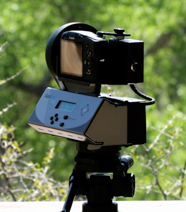
The GigaPan EPIC is a programmable picture-taking robot. You simply mount your point-and-shoot digital camera (mine is a Canon SX110 IS), set it to full zoom, set the limits of the area you want and go. The included GigaPan software running on your Mac or PC will take the resulting set of photos and stitch them together to form a very large panorama. They can then be uploaded to the GigaPan site and even linked to Google Earth and located in the place they were taken.
Zoom into and explore each one with the individual controls. Images range in size from .1 to 3.5 gigapixels. More and larger pans to come!
Notes: I am developing some tips on use of the GigaPan unit and software.
Another crystal-clear February day provided this view of Phoenix. Find Chase Field, the airport control tower, Camelback Mountain and Piestewa Peak. A geo-located view may be found at this Google Earth .kml location or launch the full-page viewer.
Downtown Phoenix, AZ from Dobbins Lookout on South Mountain
At a viewpoint off Airport Road, west of downtown Sedona provides this view of the red rock formations. This was not taken with the GigaPan Epic, but was stitched using the software. A geo-located view may be found at this Google Earth .kml location or launch the full-page viewer.
Airport Road View of Sedona, AZ
The Gigapan system was developed by Carnegie Mellon University in collaboration with NASA Ames Intelligent Robotics Group, with support from Google.
Viewed from the parking lot of Rustler's Rooste, next to the Arizona Grand Resort (formerly the Pointe Hilton), snow-capped mountains are off in the distance, the only sign that it is winter to the golfers on the resort course. Mountains visible are, from the left, Piestewa Peak, Camelback, McDowell Mountains, Red Mountain and the Superstition Mountains. Most of Tempe can be seen, including the ASU campus, Sun Devil Stadium, the new high-rise buildings along the 'lake' formed in the Salt River bed. First big pan done with my new SX110 IS and GigaPan Epic. A geo-located view may be found at this Google Earth .kml location or launch the full-page viewer.
Tempe, AZ

The southern Phoenix "urban village" of Ahwatukee Foothills as seen from on top of one of the foothills on the south side of South Mountain. This land was un-developed as a residential community twenty five years ago. The owner of much of this land had been International Harvester who operated a proving ground for their heavy equipment. Close to 85,000 people live here in the 'world's largest cul-de-sac' that is isolated from downtown Phoenix by South Mountain. This hilltop is 3.5mi from the exit off of I-10 and is halfway to the last home in the west end of the village. To the south is the Gila River Indian Community, some of which has been developed as a casino and resort. A geo-located view may be found at this Google Earth .kml location or launch the full-page viewer.
Phoenix, AZ - Ahwatukee Foothills
Tempe's ASU campus borders on an artificial lake created by damming the Salt River with inflatable barriers. Development on the lakefront, called Hayden Ferry Landing, has many high-rise buildings: expensive condos and office buildings. Winter rains have returned the grass to the north side of "A" Mountain. A geo-located view may be found at this Google Earth .kml location or launch the full-page viewer.
Tempe Town Lake, AZ
Queen Creek Canyon is one of the dramatic vistas on the trail that loops through this amazing collection of desert plants. Along Queen Creek, the cottonwood trees have sprouted their brilliant green spring foliage. The Picket Post House crowns the top of the rocks at the left. This was the mansion built by Col. Boyce Thompson in 1928 and is now being managed by Arizona State Parks. Boyce Thompson Arboretum is a non-profit organization founded in 1924 by businessman and philanthropist, William Boyce Thompson. A geo-located view may be found at this Google Earth .kml location or launch the full-page viewer.
Boyce Thompson Arboretum - Superior, AZ
The ridgeline at the center of South Mountain Park offers a full view of the Phoenix area. From snow capped peaks 50 miles to the east to the open desert of the west this 360 degree pano shows it all. It was not a perfectly clear day but you can still see the snow on Mount Lemmon, over 90 miles away to the south. In downtown, among the high rises you can see a gigantic portrait of Yao Ming, put on the side of the building across from the site of the NBA Allstar Game as part of an advertisement for T-Mobile. All four major sports venues are visible as well as ASU's Sun Devil Stadium. A geo-located view may be found at this Google Earth .kml location or launch the full-page viewer.
Phoenix, AZ - Metropolitan Area from South Mountain Park
Upstream dam releases on the Salt River have required that Town Lake release some of its water, much to the delight of the local bird population. The Salt River downstream of the dam spends most of the year completely dry. A geo-located view may be found at this Google Earth .kml location or launch the full-page viewer.
Tempe, AZ - Town Lake Waterfall
City of Phoenix Papago Park features sandstone buttes, hiking trails, picnic ramadas and a classic public golf course. A geo-located view may be found at this Google Earth .kml location or launch the full-page viewer.
Phoenix, AZ - Papago Park
High-rise commercial and residental development on the shore of Tempe Town Lake. ASU campus lies beyond the hill. The bridge to the right is Mill Avenue, named for the Hayden Flour Mill and Silos that can be seen to the right behind the KPMG building. This concrete mill was built in 1918 by Carl Hayden, replacing two earlier wooden structures destroyed by fire. Concrete silos were added in 1951. Mr. Hayden also operated a ferry across the Salt River at this site. At that time, the first dam had been put in place far upstream and the need for a ferry diminished, but the mill continued in operation until 1998. The mill and silos are being restored and a collection of boutiques and restaurants will be added in an adjacent building. A geo-located view may be found at this Google Earth .kml location or launch the full-page viewer.
Tempe, AZ - Hayden Ferry Landing
A controlled burn on the North Rim provides the smoky backdrop. A geo-located view may be found at this Google Earth .kml location or launch the full-page viewer.
Grand Canyon, AZ - Hopi Point
No water shortage here. Saguaro Lake is at the 98% full level and boaters love it. All reservoirs on the Salt River are full. Yellow-flowered brittle bush plants cover the ground between the saguaros. After all, this IS a National Forest.
This is my largest pano yet, taken with a Gigapan EPIC and a modified bracket to hold a Canon EOS XTi with a 75-300mm zoom. A geo-located view may be found at this Google Earth .kml location or launch the full-page viewer.
Tonto National Forest, AZ - Saguaro Lake
View from the greenbelt of the East Lake. 4th in a series that show the two lakes in the Lakewood subdivision. A geo-located view may be found at this Google Earth .kml location or launch the full-page viewer.
Lakewood 4 - Phoenix, AZ
View of the East Lake from the north end. A geo-located view may be found at this Google Earth .kml location or launch the full-page viewer.
Lakewood 3 - Phoenix, AZ
View of the West Lake from the greenbelt back toward where Lakewood 1 pan was shot. A geo-located view may be found at this Google Earth .kml location or launch the full-page viewer.
Lakewood 2 - Phoenix, AZ
A crystal-clear and cool February day provided this view of one of the two man-made lakes near my home. Zoom into this view and find the Mudhens and the fountain. A geo-located view may be found at this Google Earth .kml location or launch the full-page viewer.
Lakewood 1 - Phoenix, AZ
Known to most Arizonans as "Rocky Point," this beautiful, endless stretch of beach offers a cool respite for "Zonies" trying to escape the furnace. Las Conchas is a private community of beach homes and condominiums. Great fresh seafood, especially shrimp, is available right off the boat in the old town. A geo-located view may be found at this Google Earth .kml location or launch the full-page viewer.
Las Conchas - Puerto Penasco, Sonora, Mexico
A re-spin of Lakewood 1, but using all of the 360 degree photos. New version stitcher 0.4.4329 fixed the problem preventing proper 360 degree rendering and it stitched quickly and perfectly. Thanks GigaPan Team! A geo-located view may be found at this Google Earth .kml location or launch the full-page viewer.
Lakewood 1 full 360 - Phoenix, AZ
The marvelous glass work of Dale Chihuly has been on display at the Desert Botanical Garden in Phoenix since last November. A geo-located view may be found at this Google Earth .kml location or launch the full-page viewer.
Phoenix, AZ - Desert Botanical Garden Chihuly Exhibit: 'The Sun'
The marvelous glass work of Dale Chihuly has been on display at the Desert Botanical Garden in Phoenix since last November. A geo-located view may be found at this Google Earth .kml location or launch the full-page viewer.
Phoenix, AZ - Desert Botanical Garden Chihuly Exhibit: 'Blue Marlins'
The marvelous glass work of Dale Chihuly has been on display at the Desert Botanical Garden in Phoenix since last November. A geo-located view may be found at this Google Earth .kml location or launch the full-page viewer.
Phoenix, AZ - Desert Botanical Garden Chihuly Exhibit: 'Blue and Purple Boat’
The marvelous glass work of Dale Chihuly has been on display at the Desert Botanical Garden in Phoenix since last November. I have taken four GigaPans of some of the pieces before this temporary installation goes back on the road at the end of May. :-( "Red Reeds" and "Black Saguaros" are in the background on the left.
See if you can find the dove and a flying bumble-bee. Also look for this GigaPanner's reflections in some of the floats. (I am wearing a floppy hat.) A geo-located view may be found at this Google Earth .kml location or launch the full-page viewer.
Phoenix, AZ - Desert Botanical Garden Chihuly Exhibit: 'Float Boat'
Completed in 1927, this Roman Catholic church has been recently restored for the 150th anniversary of its founding. I grew up in this town and this beautiful church is where I was baptized, confirmed and married. The stained glass windows, over 50 of them, portray scenes from the Old and New Testament of the Bible and are often used to illustrate the subjects of the sermons during Mass. The only lighting in this photo is from the sunlight coming through the windows. The German company, Franz Mayer of Munich was the designer and builder of the windows. A geo-located view may be found at this Google Earth .kml location or launch the full-page viewer.
Bristol, RI - St. Mary’s Church